
Built for Harsh Environments and Data Integrity
At ARA Robotics, we proudly design, engineer, and manufacture our drones in Canada, ensuring reliability, performance, and security at every step.
.png)

40mins
Max Flight Time
45km/h
Wind Resistance
2.6kg
Max Payload Weight
-40°C to 50°C
Operating Temperature
IP54
IP Rating
40mins
Max Flight Time
45km/h
Wind Resistance
-40°C to 50°C
Operating Temperature
2.6kg
Max Payload Weight
IP54
IP Rating
40mins
Max Flight Time
45km/h
Wind Resistance
2.6kg
Max Payload Weight
-40°C to 50°C
Operating Temperature
IP54
IP Rating
40mins
Max Flight Time
45km/h
Wind Resistance
-40°C to 50°C
Operating Temperature
2.6kg
Max Payload Weight
IP54
IP Rating
40mins
Max Flight Time
45km/h
Wind Resistance
2.6kg
Max Payload Weight
-40°C to 50°C
Operating Temperature
IP54
IP Rating
40mins
Max Flight Time
45km/h
Wind Resistance
-40°C to 50°C
Operating Temperature
2.6kg
Max Payload Weight
IP54
IP Rating
2.4GHz
Frequency
6m/s
Ascent Speed
3m/s
Descent Speed
20m/s
Cruising Speed
RTK
PPK & Dual RTK Support
2.4GHz
Transmission Perimeter
6m/s
Ascent Speed
3m/s
Descent Speed
20m/s
Cruising Speed
RTK
PPK & Dual RTK Support
2.4GHz
Frequency
6m/s
Ascent Speed
3m/s
Descent Speed
20m/s
Cruising Speed
RTK
PPK & Dual RTK Support
2.4GHz
Transmission Perimeter
6m/s
Ascent Speed
3m/s
Descent Speed
20m/s
Cruising Speed
RTK
PPK & Dual RTK Support
2.4GHz
Frequency
6m/s
Ascent Speed
3m/s
Descent Speed
20m/s
Cruising Speed
RTK
PPK & Dual RTK Support
2.4GHz
Transmission Perimeter
6m/s
Ascent Speed
3m/s
Descent Speed
20m/s
Cruising Speed
RTK
PPK & Dual RTK Support
Up to 20G Resistant | Aerospace-Grade Connectors
<1.5 cm Accuracy with RTK Base Station
Up to 8 Hours of Continuous Flight Logging
Operating temperature -40°C to 50 °C
Optimized for Full Flight Automation & Multiple Modes
Flexible Fail-Safe Actions – Configurable In-Flight
Adaptive Geofencing Without Restrictive Boundaries
Advanced Control - Precise Navigation - Proven Reliability
Up to 20G Resistant | Aerospace-Grade Connectors
<1.5 cm Accuracy with RTK Base Station
Up to 8 Hours of Continuous Flight Logging
Operating temperature -40°C to 50°C
Optimized for Full Automation & Multiple Flight Modes
Flexible Fail-Safe Actions – Configurable In-Flight
Adaptive Geofencing Without Restrictive Boundaries
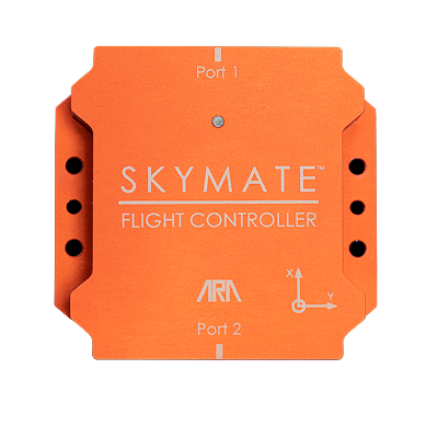
SKYMATE™ - Commercial Grade
Flight Controller
SKYMATE™ is an easy-to-use, commercial-grade flight controller, proven worldwide across a wide range of missions and environments. Purpose-built for operational efficiency, its factory-calibration ensures unprecedented navigation robustness with no need for on-site calibration. Equipped with dual RTK GNSS heading for superior resistance to interference and redundant GNSS/IMU systems for enhanced safety, SKYMATE™ delivers reliable performance in the most demanding conditions.
Built for transparency and reliability SKYMATE™ gives operators the confidence and control essential for mission-critical operations—where safety, data integrity, and continuity define success.
SKYMATE™
ARA Robotics Proprietary Hardware and Firmware
Up to 20G Resistant | Aerospace-Grade Connectors
<1.5 cm Accuracy with RTK Base Station
Up to 8 Hours of Continuous Flight Logging
Operating temperature -40°C to 50 °C
Optimized for Full Flight Automation & Multiple Modes
Flexible Fail-Safe Actions – Configurable In-Flight
Adaptive Geofencing Without Restrictive Boundaries
Advanced Control - Precise Navigation - Proven Reliability

.png)

ARA Robotics Proprietary Hardware and Firmware
Up to 20G Resistant | Aerospace-Grade Connectors
<1.5 cm Accuracy with RTK Base Station
Up to 8 Hours of Continuous Flight Logging
Operating temperature -40°C to 50°C
Optimized for Full Automation & Multiple Flight Modes
Flexible Fail-Safe Actions – Configurable In-Flight
Adaptive Geofencing Without Restrictive Boundaries
SKYMATE™ - Commercial Grade Flight Controller
SKYMATE™ is an easy-to-use, commercial-grade flight controller, proven worldwide across a wide range of missions and environments. Purpose-built for operational efficiency, its factory-calibration ensures unprecedented navigation robustness with no need for on-site calibration. Equipped with dual RTK GNSS heading for superior resistance to interference and redundant GNSS/IMU systems for enhanced safety, SKYMATE™ delivers reliable performance in the most demanding conditions.
Built for transparency and reliability SKYMATE™ gives operators the confidence and control essential for mission-critical operations—where safety, data integrity, and continuity define success.
built in edge-computing
Real Time Intelligence for Mission Critical Information
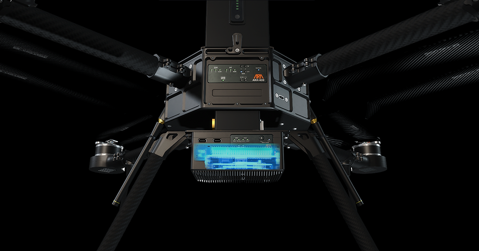
AI Module
Supports:


Using advanced image processing techniques, the AiM filters unwanted data and displays only what truly matters, to make faster, more informed decisions. Whether it’s highlighting pixels within a defined temperature range, detecting and tracking objects of interest, or overlaying mission-relevant information directly onto the live video feed, the AiM transforms raw data into actionable intelligence.
Video Overlay for Data Intelligence

With its flexible software architecture, the AiM seamlessly integrates with a wide range of payloads to support diverse mission profiles. It is fully compatible with EO/IR camera payloads for intelligence, surveillance, and wildfire monitoring, while also supporting high-resolution cameras for photogrammetry, 3D mapping, and critical infrastructure inspections.
Real Time Intelligence for Mission Critical Information

Video Overlay for Data Intelligence
Using advanced image processing techniques, the AiM filters unwanted data and displays only what truly matters, to make faster, more informed decisions. Whether it’s highlighting pixels within a defined temperature range, detecting and tracking objects of interest, or overlaying mission-relevant information directly onto the live video feed, the AiM transforms raw data into actionable intelligence.
Real Time Intelligence for Mission Critical Information
With its flexible software architecture, the AiM seamlessly integrates with a wide range of payloads to support diverse mission profiles. It is fully compatible with EO/IR camera payloads for intelligence, surveillance, and wildfire monitoring, while also supporting high-resolution cameras for photogrammetry, 3D mapping, and critical infrastructure inspections.
Reliable Detection and Tracking
A visible imaging camera combined with the AiM allows operators to detect, track, and quickly locate missing individuals during search-and rescue operations. Onboard infrared (IR) imaging further extends capabilities to environmental surveying, enabling responders to detect and localize hotpots during wildfire operations.

Reliable Detection and Tracking
A visible imaging camera combined with the AI Module (AiM) allows operators to detect, track, and quickly locate missing individuals during search-and rescue operations. Onboard infrared (IR) imaging further extends capabilities to environmental surveying, enabling responders to detect and localize hotpots during wildfire operations.

mission specific payloads
Smart Payload Integration. Simple User Experience

Ruggedized Transport Case
Security - SAR - Wildfires
The SKB rSeries 2727-18 Transport Case is a rugged, military-standard container built to protect sensitive gear in demanding conditions. With a rotomolded shell, gasket-sealed design meeting MIL-STD-C-4150J, and a built-in pressure relief valve, it delivers airtight, waterproof, and dust-tight protection. Durable hardware, secure latches, and customizable foam ensure reliable, versatile transport for mission-critical equipment.

Portable Long Range Radio
The Lenovo Legion Go Handheld Controller is a user-friendly touch-screen device, built for efficiency. Designed for field operations, it provides up to 2 hours of continuous use on a single charge, ensuring reliable performance without interruption. With its intuitive interface and SkyControl™ GCS compatibility, the controller delivers seamless mission control in a compact, portable form factor.
Inspection - Survey - Monitoring

All-In-One Controller
Gremsy Vio series is an advanced lightweight EO/IR payload, featuring a 4K zoom sensor, a 640x512 radiometric thermal camera, and an integrated 2400m laser rangefinder, ready for various industrial applications.
Intelligence, Surveillance, and Reconnaissance (ISR)
Target Acquisition and Tracking
Search and Rescue (SAR) Operations
Perimeter and Border Surveillance
Security - SAR - Wildfires

Security - SAR - Wildfires
Gremsy Vio series is an advanced lightweight EO/IR payload, featuring a 4K zoom sensor, a 640x512 radiometric thermal camera, and an integrated 2400m laser rangefinder, ready for various industrial applications.
-
Intelligence, Surveillance, and Reconnaissance (ISR)
-
Target Acquisition and Tracking
-
Search and Rescue (SAR) Operations
-
Perimeter and Border Surveillance
Gremsy VIO F1

Inspection - Survey - Monitoring
The Gremsy Pixy LR is a lightweight, military-grade gimbal optimized for high-resolution aerial intelligence. Engineered for endurance and stealth, its low-profile design enables extended ISR missions with minimal drone payload impact.
-
Accurate Infrastructure Inspection
-
High Resolution 3D Mapping
-
Battle Damage Assessment (BDA)
-
Urban Environment Monitoring and Detection
Sony ILX-LR1

Security - SAR - Wildfires
Gremsy VIO F1
Gremsy Vio series is an advanced lightweight EO/IR payload, featuring a 4K zoom sensor, a 640x512 radiometric thermal camera, and an integrated 2400m laser rangefinder, ready for various industrial applications.
Intelligence, Surveillance, and Reconnaissance (ISR)
Target Acquisition and Tracking
Search and Rescue (SAR) Operations
Perimeter and Border Surveillance

Inspection - Survey - Monitoring
Sony ILX-LR1
The Gremsy Pixy LR is a lightweight, military-grade gimbal optimized for high-resolution aerial intelligence. Engineered for endurance and stealth, its low-profile design enables extended ISR missions with minimal drone payload impact.
-
Accurate Infrastructure Inspection
-
High Resolution 3D Mapping
-
Battle Damage Assessment (BDA)
-
Urban Environment Monitoring and Detection
Security - SAR - Wildfires
Gremsy VIO F1
Gremsy Vio series is an advanced lightweight EO/IR payload, featuring a 4K zoom sensor, a 640x512 radiometric thermal camera, and an integrated 2400m laser rangefinder, ready for various industrial applications.
Intelligence, Surveillance, and Reconnaissance (ISR)
Target Acquisition and Tracking
Search and Rescue (SAR) Operations
Perimeter and Border Surveillance

ACCESSORIES
Plug-and-Play Accessories for Effortless Operations
Portable Long Range Radio
The Doodle Labs Wearable Mesh Rider Radio is a compact, rugged device built for mission-critical field operations. With its IP68-rated design and Mesh Rider® waveform technology, it delivers secure, high-bandwidth connectivity in harsh environments. Offering multi-band support, Wi-Fi hotspot bridging, and AES-256 encryption, the Wearable ensures reliable team communications with low latency and extended range—all in a lightweight, portable form factor.
All-in-one Controller
The Lenovo Legion Go Handheld Controller is a user-friendly touch-screen device, built for efficiency. Designed for field operations, it provides up to 2 hours of continuous use on a single charge, ensuring reliable performance without interruption. With its intuitive interface and SkyControl™ GCS compatibility, the controller delivers seamless mission control in a compact, portable form factor.

Ruggedized Transport Case
The SKB rSeries 2727-18 Transport Case is a rugged, military-standard container built to protect sensitive gear in demanding conditions. With a rotomolded shell, gasket-sealed design meeting MIL-STD-C-4150J, and a built-in pressure relief valve, it delivers airtight, waterproof, and dust-tight protection. Durable hardware, secure latches, and customizable foam ensure reliable, versatile transport for mission-critical equipment.
Ground Control
Station software
Smart Control. Easy to Use
Mobile View

Fly - Monitor - Configure
Desktop View

Operate - Plan - Monitor - Configure - Extract
SKYCONTROL™ serves as the central hub for real-time monitoring, mission planning and configuration of your ARA RPAS. It provides key systems visualization, seamless integration on external networks and radios and ensures situation awareness via FPV and camera feed visualization. SKYCONTROL™ allows a single operator to manage multiples efficiently with automated safety protocols, while remaining user-friendly for rapid deployment in diverse mission contexts. Additionally, SKYCONTROL™ is deployable in two versions, one for PC and one for touch-screen handheld controllers.
![Drone ARA-408 [summer 2024]_edited.jpg](https://static.wixstatic.com/media/d75a34_7587384f904142c095313f1b33cf9f5b~mv2.jpg/v1/fill/w_160,h_50,al_c,q_80,usm_0.66_1.00_0.01,enc_avif,quality_auto/d75a34_7587384f904142c095313f1b33cf9f5b~mv2.jpg)